Professor Patrick Hesp leads a team of researchers from Flinders University at the Coorong Lower Lakes and Murray Mouth Research Centre (CLLMMRC) examining coastal dune systems in the region.
The Younghusband Peninsula is the longest coastal dune system in Australia. It extends 190 km from the Murray River mouth at Goolwa to Kingston in the state’s southeast. This Peninsula and Wuyung/Sir Richard Peninsula (~10km, from Goolwa South to Murray mouth) have acted as barriers between the Southern Ocean and the Coorong Lagoon for over seven thousand years.
Large dune systems, such as those protecting the Coorong, are formed by sediment being transported by waves from the ocean and the surf zone (where waves break). Once waves deposit the sand on the beach, the wind transports it landwards, creating dunes.
“Sand dunes are formed by wind and water, and while they are always dynamic, the Coorong is currently in a period of stabilisation due to increasing vegetation cover,” says Professor Patrick Hesp.
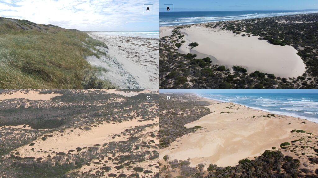
A) Foredune at Rivoli Bay. Foredunes are created when wind blows sediment into pioneer plants on the backshore of beaches. If there’s a high sediment supply and low to moderate waves and winds, foredune plains can form like those at Rivoli Bay.
B) Parabolic dune (recent, 260m long) at Godfrey’s Landing. Parabolic dunes are also known as blowout dunes and have a characteristic V or U shape. They can form in high sediment, high wind and high wave environments.
C) Parabolic dune (600m long) in Younghusband Peninsula
D) Trangressive dunefield (recent) near 42 Mile Crossing. Trangressive dunefields, also known as sand seas, are also formed in high sediment, wind and wave environments.
Prof Hesp and his team used historical surveys and aerial photographs to see how the dune systems and their vegetation have changed over time. Their research found that the Coorong dune system is currently in a stable period due to vegetation cover, which they estimate has increased by 30% between 1945 and 2025.
Vegetation is vital to dune stability but not all plants are created equal. Native plants like spinifex help to steady the movement of sand and develop habitat for wildlife, while others like the invasive sea wheat grass can displace native vegetation and damage hooded plover nests.
“Invasive species are highly drought adaptive for semi-arid regions and have very rapid root growth rates, producing massive amounts of seeds – up to 10,000 from a single plant!” says Professor Hess.
Invasive plant and animal species need to be actively managed (and better understood) so that we can actively manage and protect this fragile and endangered ecosystem.
As well as looking at historical survey data and images of the dune systems, the team installed piezometers across Sir Richard Peninsula to observe hydrogeological changes. First Nations cultural monitors worked in the field with the project team to make sure that all proposed piezometer sites were cleared for installation. As well as using the piezometers to monitor characteristics like groundwater levels, salinity, groundwater wave propagation and dune responses, they also used the sediment collected during drilling to determine the age structure of the barrier.
The team used the information they collected to put together a tentative evolutionary history of the Sir Richard Peninsula. They found that the coastal barrier initially migrated landward (retrogradation) over a palaeo-lagoon or palaeo-river system before migrating seaward (progradation) 4,000 to 3,000 years before present.
Over the last 3000 years, the barrier spit has also moved seaward (prograded) several kilometres alongshore to its current position opposite Sugars Beach.
There’s no question that the beach-dune systems will continue to change in the CLLMM region. But what will that look like as the climate changes and sea levels rise?
For the first time, the piezometer network will enable us to monitor groundwater levels, salinity, and groundwater wave propagation on the Sir Richard Peninsula over time.
This network can also be built on by others investigating dune and beach ecology on the surface, layering plant and animal information from the same region on top of this hydrogeological foundation.
As more data is collected, we’ll be able to build a clearer picture of the fragile ecosystem and how we can best manage and protect it.